
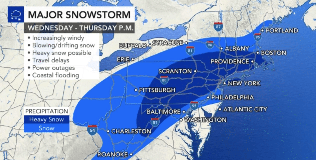
(ETH) – A major nor’easter is expected to take shape at midweek and unload the biggest snowstorm in years across a good portion of the Northeast. Snowfall totals are expected to be measured in feet in some areas across the interior as winds ramp up and create near-blizzard conditions for parts of the region late Wednesday into Thursday morning.
But, one factor will keep the storm from becoming a full-on “snowmaggedon,” and that will be its forward speed. It’ll be a fast-moving storm, which will keep overall snow totals down. Even still, at the storm’s peak, snow is expected to come down at a rate of 1 to 3 inches per hour.
“All the ingredients are now coming together for our snowstorm, and I really don’t see a way out of this for many cities across the Northeast,” AccuWeather Chief On-Air Meteorologist Bernie Rayno said. A fresh injection of cold air is already in place ahead of the storm, Rayno explained, adding, “You can already feel it.” When Atlantic moisture gets pulled into the storm off the coast on Wednesday, that’s when the storm will really get going, he added. READ MORE
Winter Storm Gail could bring some Northeast cities more snow in a day or two than they saw all of last winter. Winter 2019-20 produced paltry snowfall amounts in many Northeast cities.
In some cases, even a small amount of snow from Gail could top last season’s totals. New York City’s Central Park only picked up 4.8 inches of snow all of last winter, 21 inches fewer than an average snow season and only 2 inches more than their least snowy season on record, 1972-73.
Only three other seasons since 1869 were less snowy than 2019-20 in New York. The deficit was even larger in Allentown, Pennsylvania, where snowfall was 27.6 inches below average. Last season’s total of 5.3 inches also ranked as the least snowy on record in the city. READ MORE


