
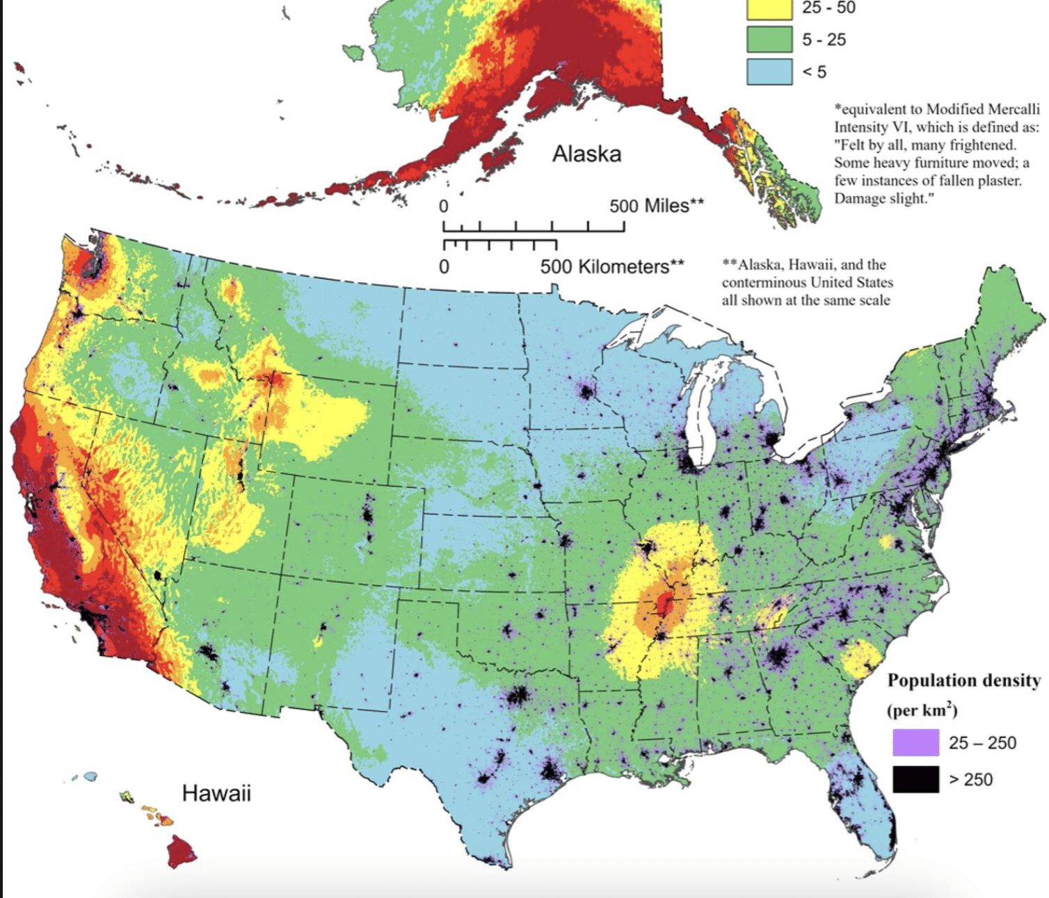
Nearly 75% of the U.S. could experience damaging earthquake shaking, according to a recent U.S. Geological Survey-led team of more than 50 scientists and engineers.
This was one of several key findings from the latest USGS National Seismic Hazard Model (NSHM). The model was used to create a color-coded map that pinpoints where damaging earthquakes are most likely to occur based on insights from seismic studies, historical geologic data, and the latest data-collection technologies.
The research is published in the journal Earthquake Spectra.
The congressionally requested NSHM update was created as an essential tool to help engineers and others mitigate how earthquakes affect the most vulnerable communities by showing likely earthquake locations and how much shaking they might produce. New tools and technology identified nearly 500 additional faults that could produce a damaging quake, showcasing the evolving landscape of earthquake research.
“This was a massive, multi-year collaborative effort between federal, state and local governments and the private sector,” said Mark Petersen, USGS geophysicist and lead author of the study. “The new seismic hazard model represents a touchstone achievement for enhancing public safety.”
The latest iteration, the first 50-state comprehensive assessment, was updated from previous versions published in 2018 (conterminous U.S.), 2007 (Alaska) and 1998 (Hawaii).
Noteworthy changes in the new model show the possibility of more damaging earthquakes along the central and northeastern Atlantic Coastal corridor, including in the cities of Washington D.C., Philadelphia, New York and Boston.
In addition, there is a chance for greater shaking in the seismically active regions of California and Alaska. The new model also characterizes Hawai’i as having greater potential for shaking because of observations from recent volcanic eruptions and seismic unrest on the islands.
“Earthquakes are difficult to forecast but we’ve made great strides with this new model,” said Petersen. “The update includes more faults, better-characterized land surfaces, and computational advancements in modeling that provide the most detailed view ever of the earthquake risks we face.”


