
A dangerous storm system is slamming California, with meteorologists at the National Weather Service warning of imminent “widespread flooding, impassible roads, mudslides/landslides [and] rapid rises in rivers/creeks.”
According to MSN, The system, which prompted the Weather Service to take the unusual step of urging residents to have “go bags” at the ready and prepare insurance documentation in advance, is set to unleash its harshest conditions Wednesday night into early Thursday.
Virtually the entirety of Northern and Central California is under flood watches and high-wind warnings, with damaging gusts to 60 mph possible. Strong to severe thunderstorms could be in the offing as well, in addition to 2 to 4 inches of rain in the lowlands and more in the mountains. In the highest terrain, the heavy rain will transition to up to 2 to 4 feet of heavy snow. Along the coast, beaches will be battered by large waves and areas of coastal flooding.
Southern California will see heavy rain, strong winds, hazardous surf along the coast and the potential for flooding, too, especially from Los Angeles northward Wednesday night into Thursday.
The disruptive storm comes on the heels of a barrage of other atmospheric rivers, which dropped 11.6 inches of rain on San Francisco in December. The already saturated soils will make renewed flooding occur more quickly, and make it easier for trees to be uprooted. “Damaging winds will blow down trees and power lines,” the Weather Service warned. “Widespread power outages are expected.”
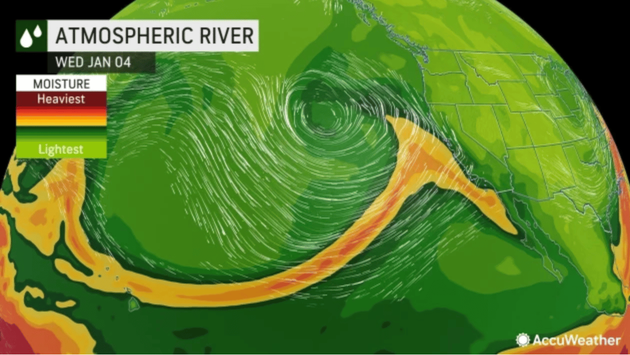
This major storm will rapidly intensify and become a bomb cyclone off the coast of California will slam into the Golden State, unleashing an increasing risk for life-threatening flooding, damaging winds and power outages into Thursday, AccuWeather meteorologists warn.
The storm will affect California just days after the deadly flooding and heavy snow that developed in the state over the holiday weekend, threatening travelers and causing hundreds of thousands of power outages.
Travel conditions will deteriorate rapidly over much of California during Wednesday night and may be difficult and dangerous in many areas by Thursday morning for a variety of reasons.
“There is a significant risk for flash flooding, and people should watch for and avoid rapidly rising water which can quickly become life-threatening,” AccuWeather Chief Meteorologist Jon Porter said, adding that flooding may result in street and highway closures. “This will be a dangerous and high-impact storm for California, capable of producing life-threatening conditions and significant disruption which may last several days.”
Mudslides are among the dangers that can persist for several days even after the rain ends, Porter explained. “Not only will this storm be intense tapping into a substantial atmospheric river, but it is also arriving just days after the previous storm brought heavy rainfall and created significant flooding, increasing the impacts and risks that can occur,” he said.
The rapid intensification of the storm, in a process known as bombogenesis, will add to the dangers it poses, including strong winds on top of the extreme precipitation. When the barometric pressure falls at least 0.71 of an inch (24 millibars) in 24 hours, a storm has undergone bombogenesis, and meteorologists will often refer to this type of strengthening system as a bomb cyclone. From Tuesday morning to Wednesday morning, the central pressure in the storm plummeted 0.86 of an inch of mercury (29 millibars) and exceeded the official criteria for a bomb cyclone.


