
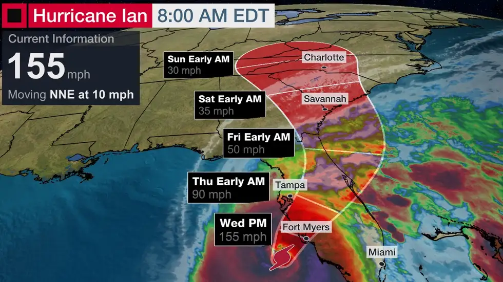
Hurricane Ian remains an extremely dangerous Category 4 storm as of the 8 a.m. Eastern time advisory from the National Hurricane Center. Maximum sustained winds were estimated at 155 mph, which means Ian is just 2 mph shy of becoming a Category 5 hurricane.
According to Fox Weather, Ian is forecast to make landfall in Southwest Florida as a catastrophic hurricane on Wednesday afternoon with destructive winds, life-threatening storm surge, widespread flooding and isolated tornadoes across the Florida Peninsula. Hurricane Ian is currently centered about 55 miles west of Naples, Florida, or 60 miles southwest of Punta Gorda, Florida.
Meanwhile, The governor told reporters in a briefing that current track has the storm making landfall in Charlotte County, with the highest risk areas ranging from Collier County and up to Sarasota County. “If you are in any of those counties, it’s no longer possibly to safety evacuate. It’s time to hunker down and prepare for this storm,” he urged.
Those out on the roads should get to a safe place as soon as possible. DeSantis noted that there are bridges closed and that there are more than 200 shelters open in just the southwestern region of the state.
Residents who are hunkering down should wait to go outside until the storm has passed and be cautious afterward. The governor said Ian could make landfall as a Category 5 hurricane. “So, this is a major, major storm,” he stated, adding that the strengthening of the storm overnight has been “significant.”


