
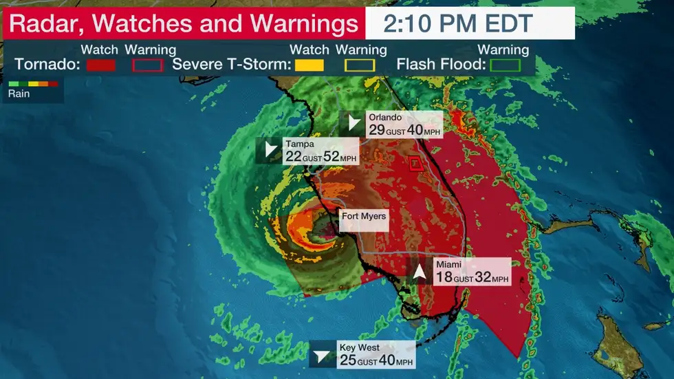
Hurricane Ian is making landfall as one of southwest Florida’s most intense hurricanes on record, expected to produce catastrophic storm surge, destructive winds, and flooding rainfall. Ian is a strong Category 4 hurricane packing maximum sustained winds of 155 mph.
Ian’s storm surge has arrived along parts of the southwest Florida coast, including in Naples, Florida, where over 6 feet of storm surge inundation has been measured, more than any other storm at that gauge location in at least 50 years.
Meanwhile, winds are blowing offshore producing a blowout tide in Tampa Bay. Water levels are around 6 feet below average and many parts of Tampa Bay are dry.
Ian’s eyewall began scraping the coast of southwest Florida Wednesday, including Sanibel Island, prompting a rarely-issued “Extreme Wind Warning” used by the National Weather Service only in situations of the most intense winds in stronger hurricanes. Winds over 115 mph are expected.
A River, Estuary, and Coastal Network station at Redfish Pass, Florida, recently reported sustained winds of 94 mph and a wind gust of 126 mph. Winds have recently gusted up to 112 mph at the Naples Grande Beach Resort, 107 mph near Sanibel Island, and 79 mph in Punta Gorda.
Gusts over 40 mph have been clocked on the Atlantic side, including a 54 mph gust at Cape Canaveral. Street flooding was reported in Stuart, about 100 miles north of Miami. A tornado watch is in effect for central and southern Florida until 5 p.m. EDT.
Hurricane warnings (shaded in purple in the map below) now stretch across the Florida Peninsula from southwest to central to Florida’s Space Coast, including Tampa-St. Petersburg, Fort Myers, Orlando and Daytona Beach. This means hurricane conditions are expected.
A storm surge warning is also in effect along much of Florida’s west coast, from the mouth of the Suwanee River to the Lower Keys, including Tampa Bay, and also on the Atlantic side from the Flagler-Volusia County line in northeast Florida to the entire Georgia coast to Charleston County, South Carolina, including Florida’s St. Johns River. This means life-threatening flooding from rising water moving inland from the coastline is expected.
A hurricane watch extends from northeast Florida’s coast to Charleston County, South Carolina, where hurricane conditions are possible. Tropical storm warnings extend from the Florida Keys northward to southeast Florida, the northwestern Bahamas, the Florida Big Bend, and from northeastern Florida to the border of North Carolina and South Carolina, as you can see in the map below. (TWC)


