
Millions of people across California are bracing for an apocalyptic battle with Mother Nature over the coming days as a tropical storm threatens to add intense moisture to the already devastating mix of excessive heat and raging wildfires, sparked by historic drought conditions, in many parts of the state.
The record heat has put extraordinary pressure on the state’s electric-power grid as people try to cool off, causing utilities to call for voluntary cuts in service to make sure there is enough juice for fundamental infrastructure.
Now new wildfires have produced thick clouds of smoke, which have started to compromise the solar power grid by blocking sunlight. Two blazes—the Fairview Fire in Southern California and the Mosquito Fire in the Sierra—have been particularly challenging to contain. Thousands of people have been evacuated and at least two people have died while trying to escape.
As if the heat and fires weren’t challenging enough, Tropical Storm Kay, which has luckily lost its hurricane-strength punch, will make landfall in northern Baja California on Friday, which will bring welcome moisture, but accompanying chaos in the form of strong winds and flash flooding. The rain, as the storm makes its way along the West Coast, is expected to dissipate, but the winds could add dangerous new fuel to fires in Northern California and Oregon.
In parts of Southern California that have been severely drought-stricken for months, residents are bracing for a storm that could drop a year’s worth of rain — and cause dangerous flash floods.
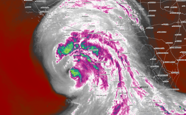
The extreme weather is forecast as Tropical Storm Kay moves northward after making landfall in Mexico as a Category 1 hurricane Thursday afternoon. Kay weakened to a tropical storm Thursday evening but was still packing winds of 50 mph with even stronger wind gusts Friday morning.
The storm is expected to bring damaging winds to Southern California, similar to a Santa Ana wind event, where gusts could reach 80 mph at the mountain crests. “Possible 50+ MPH gusts could even reach the San Diego County coast as well as in the Inland Empire,” the National Weather Service there said Friday morning. “Many other areas, including in Orange County, could have wind gusts near 50 MPH for awhile Friday.”
Those powerful, damaging winds are threatening to push already high temperatures across California even higher, extending a brutal heat wave that’s fueled raging wildfires, strained the state’s energy grid and prompted officials to urge residents to limit energy use in the hopes of avoiding rolling power outages. About 30 million Californians were under heat alerts Friday morning, with triple-digit temperatures expected during the day in the state’s interior portions. Kay is weakening, but the storm is not expected to turn away from the coast until Saturday night.
As Kay continued to churn northward, the impacts from the tropical system were predicted to be significant in parts of the U.S., specifically Southern California. On Thursday, some outer bands from Kay were already sweeping across southern portions of the Golden State. As Kay continues to move northward, rain is likely to become more widespread. Tropical moisture will help to bring thunderstorms as far inland as central Arizona and southern Nevada, impacting cities such as Phoenix and Las Vegas. However, the heaviest rain is likely to center on Southern California.
“Despite the loss of wind intensity as Kay moves northward, the impacts to California will be notable,” said AccuWeather Meteorologist Brandon Buckingham. The last-named tropical system that came close to San Diego was Hurricane Nora from September 1997. Nora made landfall as a tropical storm on the Baja Peninsula of Mexico and continued to move northeastward, with the center of the storm moving into southwestern Arizona.


