
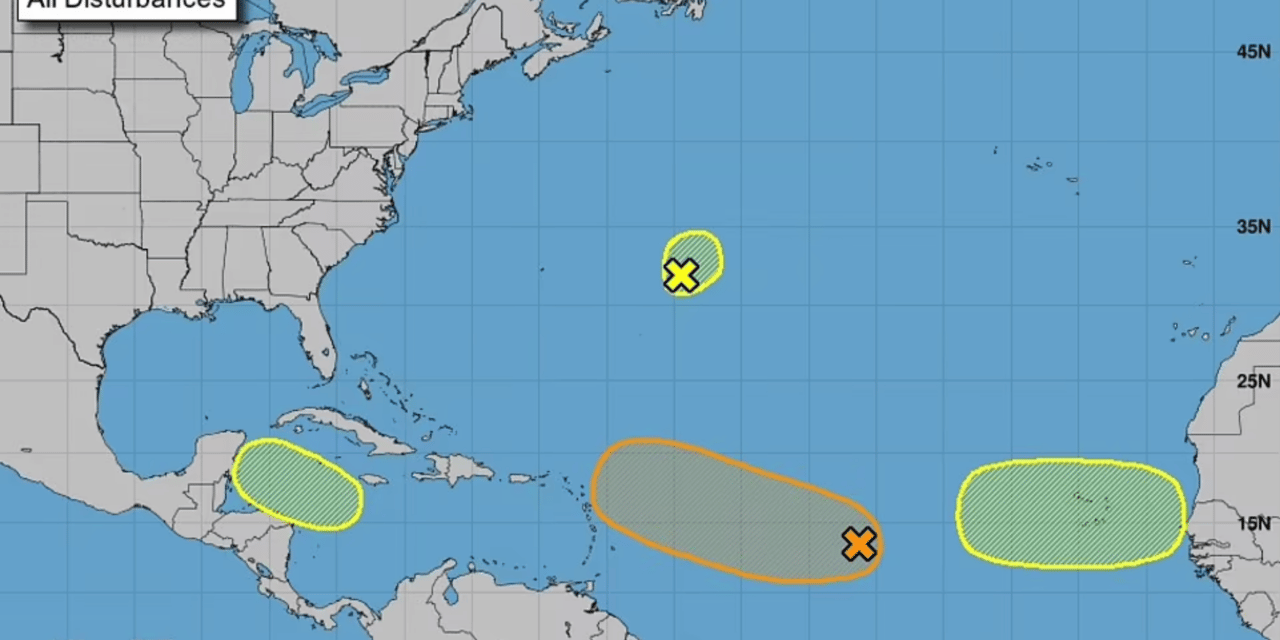
Three potential hurricanes could hit the United States in September after only the third hurricane-free August in 60 years. The nearest storm as of Monday was described by the National Hurricane Center as being in the Central Tropical Atlantic, and they estimate the chance of it becoming a hurricane within five days at 80 percent.
Two more follow: one 600 miles east of Bermuda as of 2 pm EDT on Monday, given a 10 percent chance of becoming a hurricane, and the third off the west coast of Africa, given a 30 percent chance of strengthening to a hurricane in the next five days. A fourth storm is being monitored, heading towards Mexico’s Yucatan Peninsula, but is not expected to hit the U.S. The last named storm to hit the U.S. was Tropical Storm Colin, which landed in the Carolinas on July 2.
This time last year, the U.S. had endured Tropical Storm Fred, which hit Florida on August 16 and spawned 31 tornadoes from Georgia to Massachusetts, and Hurricane Henri, which slammed into New England on August 22, flooding large swathes of the coast.
On August 29, 2021, Hurricane Ida made landfall near Port Fourchon, Louisiana, with sustained winds of 150 mph – tying the state record for the strongest landfall speeds felt with the 1856 Last Island hurricane and Hurricane Laura of 2020.
Philip Klotzbach, a hurricane researcher at Colorado State University, noted that it is the first time since 1982 that there has not been a single named storm anywhere in the Atlantic between July 3 and the penultimate week of August. The phenomena has happened five other times since 1950, making a quiet stretch this long leading up to peak season a roughly once-a-decade event.
Accuweather senior meteorologist Dan Pydynowski told USA Today it was still possible that August would have a named storm. ‘Will we get through the end of the day Wednesday (without a named storm)? It’s probably going to be a close call,’ Pydynowski said.
Accuweather’s forecast predicts 16 named storms this season: two above the average, but five fewer than in 2021. The National Oceanic and Atmospheric Administration predict six to 10 Atlantic hurricanes compared with the norm of seven, and they can come quickly in September when ocean water is at its warmest. ‘You don’t want people to let their guard down,’ said Pydynowski. ‘Just because we haven’t had any storms yet doesn’t mean we won’t.
‘And it’s not necessarily the number of storms that counts. ‘It’s: does the storm hit the U.S., and if it does, what is the intensity when it does so?’ It comes as Mississippi Governor Tate Reeves said he is declaring a state of emergency after excessive rainfall exacerbated problems in one of Jackson’s water-treatment plants and caused low water pressure in the capital.
The low pressure raised concerns about firefighting and about people’s ability to take showers or flush toilets. Reeves said that on Tuesday, the Mississippi Emergency Management Agency will start distributing both drinking water and non-potable water in the city of 150,000 residents, and the National Guard will be called in to help.
The governor said he understands people in Jackson do not want to have water system problems. ‘I get it. I live in the city. It’s not news that I want to hear,’ Reeves said. ‘But we are going to be there for you.’ A swollen Pearl River flooded streets and at least one home in Jackson on Monday, days after storms dumped heavy rain, but water levels were starting to recede.
Jackson Mayor Chokwe Antar Lumumba said the water did not rise as high as expected. Earlier projections showed about 100 to 150 buildings in the Jackson area faced the possibility of flooding. ‘We thank the Lord most of all for sparing so many of our residents,’ Lumumba said Monday, hours before the governor spoke about the water system. (Daily Mail)


