
forecasters from Accuweather have been watching out for a major severe weather outbreak since last week, and their latest forecast shows a clearer picture of how that outbreak could unfold around the middle of this week.
The severe weather outbreak will be associated with a potent storm that is forecast to swing out of the Rockies and travel across the Plains and Mississippi Valley this week, bringing snowfall to the locations to the north and west.
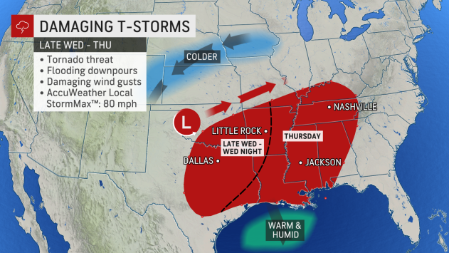
The storm’s warmer side will bring the risk of tornadoes in the south-central United States from late Wednesday afternoon through Thursday evening. A number of violent storms can occur after dark on Wednesday, AccuWeather meteorologists warn, and all forms of severe weather are possible.
The most common threats from the storms are likely to be powerful wind gusts, with an AccuWeather Local StormMax estimated to be 80 mph. There is also the risk of flash flooding and a few storms that could unleash large hail. Numerous major cities will be in the path of the explosive weather system, including Dallas and Oklahoma City, farther to the west.
The threat zone AccuWeather forecasters have highlighted extends to the east and includes Little Rock, Arkansas, Memphis and Nashville, Tennessee, and even parts of western Kentucky that were hit hard by a historic tornado outbreak in December 2021.
The National Weather Service’s Storm Prediction Center (SPC) had labeled the severe weather threat as “slight” as of midday on Monday. The slight risk is considered to be 2 on the scale from 1 to 5 with 5 posing the greatest threat. The threat level may climb into midweek. The severe weather will set up in part of the storm’s warm sector that will send temperatures to rising springlike levels in the 50s, 60s, and 70s in the East and the 60s, 70s, and 80s in the South Central States. READ MORE


