
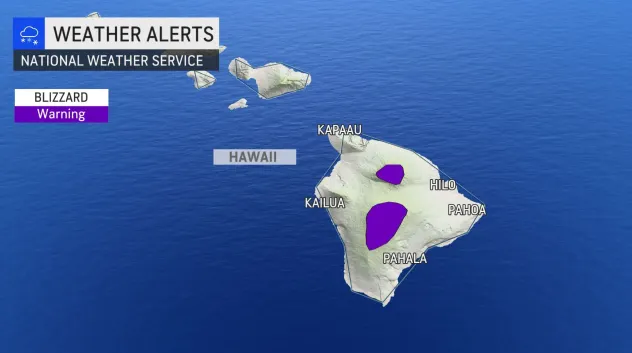
A blizzard is headed for Hawaii, and meteorologists are stunned. People reported that portions of the Big Island of Hawaii are expected to see 12 inches or more of snow and winds up to 100 mph Friday evening through Sunday morning, according to a bulletin from the National Weather Service.
“Travel could be very difficult to impossible,” the bulletin stated. “Blowing snow will significantly reduce visibility at times, with periods of zero visibility.” This unusual weather event, which will largely impact higher elevations, has surprised meteorologists across the country.
USA Today is stating that the warning remains in effect from 6 p.m. Friday until 6 a.m. Sunday as up to 12 inches or more of snow is expected on the island. NWS also warns residents to stay indoors as forecasters predict winds gusting over 100 mph. “Travel could be very difficult to impossible.
Blowing snow will significantly reduce visibility at times, with periods of zero visibility,” NWS’s weather warning reads. Aside from the blizzard warning, a Kona low is expected near the islands starting on Saturday night.
Kona storms are a type of seasonal cyclone in the Hawaiian Islands, usually formed in the winter from winds coming from the westerly “Kona” direction, according to N. Kona lows often bring about wet and “unsettled” weather.
Accuweather stated: “When winds from the east come down from the mountains, this can restrict precipitation,” explained AccuWeather Senior Meteorologist Carl Babinski. Honolulu, to the south of higher terrain, is in one such location.
However, Hilo is right at the coast on the Big Island which allows it to receive much more precipitation. Regardless of terrain, all of the islands will be in line for heavy rain over the next several days. A cold front will move from northwest to southeast across the state from Friday into Friday night.
Heavy rainfall will focus along the front. In addition, localized thunderstorms will develop, and rain can be enhanced further and cause flooding and even mudslides in any thunderstorms. The front is expected to stall on Saturday. At the same time, a low-pressure area known as a Kona low could then drop down toward the state by Sunday and Monday.


