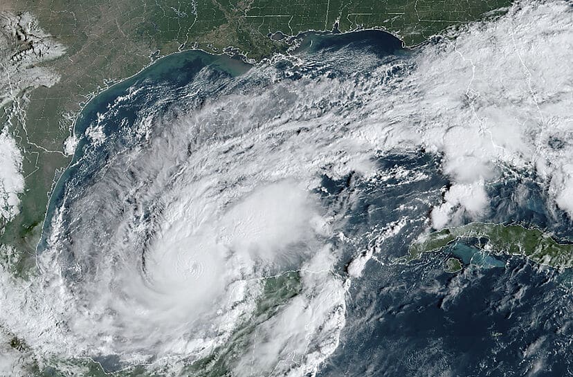
(OPINION) This normally doesn’t happen. During regular times, a hurricane is not supposed to go from Category 1 to Category 5 in less than a day.
At this moment, the roads out of the Tampa Bay area are absolutely jammed with vehicles as local residents attempt to get out of the path of the coming storm.
We literally just witnessed one of the most destructive hurricanes in U.S. history, and now we are being told that Hurricane Milton could also be one of the most destructive hurricanes in U.S. history. So what in the world is going on here?
When I woke up on Monday morning, I was shocked to learn that Hurricane Milton had developed into a Category 5 storm with sustained wins of 160 mph…
With winds of 160 mph, Milton has strengthened into the second Category 5 hurricane of the 2024 Atlantic hurricane season. Hurricane Beryl was the first storm to reach Category 5 status, doing so while it was traversing the Caribbean Sea in early July.
Milton was only a tropical storm on Sunday morning, but winds ramped up at a tremendous pace, spiking from 60 mph to 160 mph in just 28 hours. Additionally, an abundance of lighting has been flashing around the eye of Milton, an indication that it could still be strengthening.
But that wasn’t the end of it. Just a few hours later, it was being reported that Hurricane Milton had sustained winds of 175 mph…
Hurricane Milton has grown into an explosive Category 5 storm with sustained winds of 175 miles per hour, just two days after it developed in the Gulf of Mexico, forecasters said Monday.
The hurricane was expanding and intensifying quickly Monday while tracking eastward over warm Gulf waters, with the latest growth happening much faster than forecasts suggested. Milton is expected to bring life-threatening conditions to parts of Florida, potentially as early as Tuesday.
Milton’s winds surged to 175 mph Monday, exceeding the threshold for Category 5 by a significant margin, according to the latest update from the National Hurricane Center. The storm’s wind speeds more than doubled in the last 48 hours.
Of course that wasn’t the peak either. Just a little while ago, we were told that Hurricane Milton now had sustained winds of 180 mph…
Hurricane Milton strengthened to a Category 5 powerhouse Monday, driving sustained winds of 180 mph as it rolled across the Gulf of Mexico bound for what could be a devastating crash Wednesday along Florida’s already storm-battered western coast.
The National Hurricane Center said on its 5 p.m. advisory that Milton had reached those rare wind speeds, three hours after warning the hurricane had “explosively” intensified to 175 mph.
Come on now. This isn’t supposed to happen. Especially in October. On Monday alone, the storm’s winds increased by 90 mph.
That is nuts! One meteorologist was literally “on the verge of tears” as he discussed how powerful this storm was becoming… Meteorology expert John Morales was on the verge of tears as he reported on what is to come for Florida live on NBC6.
‘It’s just an incredible, incredible, incredible hurricane. It has dropped– ‘ Morales said before pausing, visibly emotional. ‘It has dropped 50 millibars in 10 hours,’ he continued. ‘I apologize. This is just horrific.’
A lot of people have been searching for “Category 6 hurricane” on Google, and USA Today published an entire article that speculated that a “hypothetical Category 6” could soon be added to the scale that we use to measure storms…
The rapidly developing hurricane that shows no signs of stopping won’t technically become a Category 6 because the category doesn’t exist at the moment.
But it could soon reach the level of a hypothetical Category 6 experts have discussed and stir up arguments about whether the National Hurricane Center’s long-used scale for classifying hurricane wind speeds from Category 1 to 5 might need an overhaul.
This is a “once in a century” storm, but of course we just witnessed a “once in a century” storm. It is so difficult to project exactly where large hurricanes will go, but right now forecasters are telling us that Hurricane Milton is heading straight toward the Tampa Bay area…
Milton is aiming directly for the Tampa Bay area—one of the state’s largest metro areas and home to more than 3 million people. The Tampa Bay area has seen its fair share of hurricanes, but the storms typically do not strike the region directly from the west from the Gulf of Mexico, instead traveling north along the coast, as seen in the paths of Hurricane Ian in 2022.
AccuWeather’s chief meteorologist Jonathan Porter called Milton’s trajectory “unusual and extremely concerning.” This is the kind of storm that can rip the roof right off a home and send trees hurtling through the air like missiles.
If Tampa takes a direct hit, the damage could be absolutely catastrophic. According to one local meteorologist, this storm has the potential to be “the worst natural disaster in modern history for Florida”…
Hurricane Milton will be the worst disaster that Florida has ever seen, a longstanding weatherman has warned. David Hartman, who works for WAPT in neighboring Mississippi, wrote: ‘Sadly, this is shaping up to the worst natural disaster in modern history for Florida.’ (READ MORE)


