
Even as Hurricane Helene was pressing toward the Florida coast, AccuWeather‘s team of expert meteorologists had been monitoring part of the Gulf of Mexico for yet another round of tropical trouble.
On Saturday afternoon, Tropical Storm Milton formed, just hours after becoming a tropical depression, and it was expected to intensify and strike the Florida Peninsula next week as a hurricane, with torrential rain, wind and the likelihood of flooding.
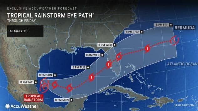
Thunderstorms have been persistently erupting in the southwestern Gulf of Mexico for the past few days. AccuWeather began to refer to the system as a tropical rainstorm late in the week to raise public awareness of the risk to lives and property and to assist in planning and preparation.
As the tropical storms continues to churn over the warm Gulf waters later this weekend and early in the new week, it is expected to strengthen into a Category 1 or 2 hurricane (on the Saffir-Simpson Hurricane Wind Scale) before making landfall just south of Tampa Bay, Florida, on Wednesday morning.
At this time, the greatest threat to lives and property appears to be due to torrential rainfall that can lead to dangerous, damaging and disruptive urban flooding in central and South Florida, beginning as early as Sunday and lasting through the middle of next week.
Besides torrential rainfall and flooding concerns, Milton can bring rough surf, dangerous seas and strong winds that cause power outages and even tornadoes.
A general 4-8 inches of rain is forecast to fall on portions of central and South Florida, with heavier rain and higher totals of 8-12 inches expected for places like Tampa and Orlando. The AccuWeather Local StormMax™ for Milton is 30 inches.
Rainfall rates of several inches per hour can occur in the major metro areas, easily overwhelming the storm drainage system in cities such as Cape Coral, Naples, Port Charlotte, Fort Myers, Tampa, St. Petersburg, Miami, Fort Lauderdale, Orlando and Melbourne.
Even though much of Florida’s soil is very sandy and can absorb heavy rain quickly, there will still be enough runoff that works into creeks, lakes and rivers to trigger flooding.
Water levels may rise quickly on the smaller streams and lakes but may take a week or two to cycle through rivers such as the Peace, Imperial, Hillsborough, Myakka and St. Johns.


