
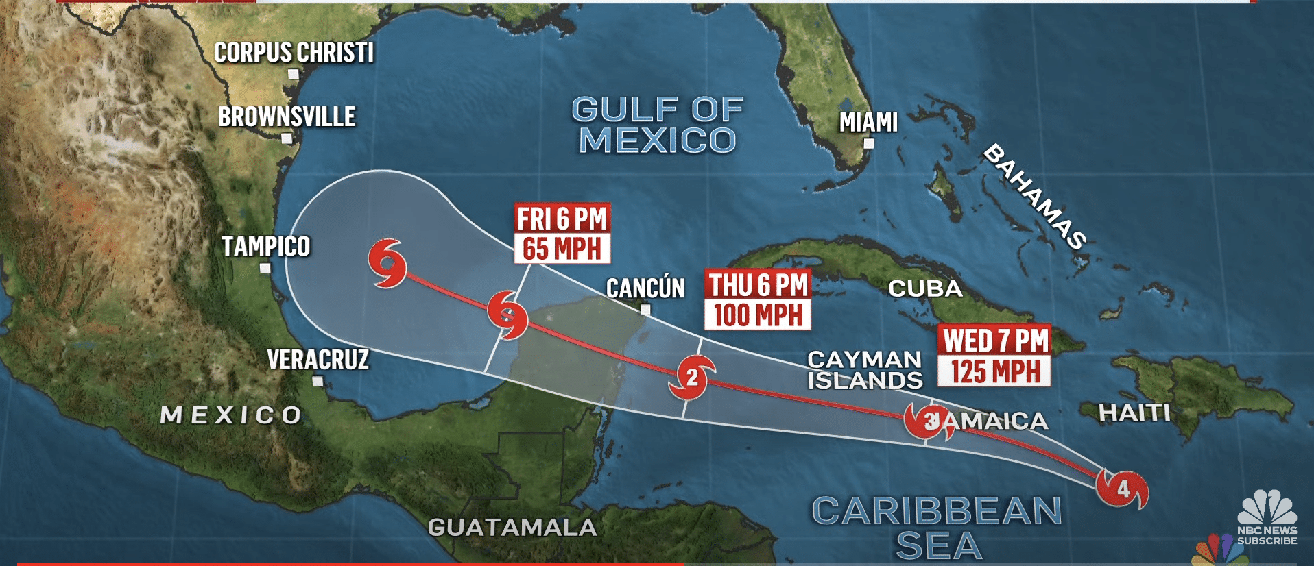
A new tropical depression formed in the Atlantic Ocean last Friday. A mere two days later it had become a monstrous Category 4 hurricane, which made landfall in Grenada’s island of Carriacou on Monday. By late that evening local time, the storm, named Beryl, was a Category 5 hurricane, the earliest ever in the Atlantic Ocean basin.
The occurrence of such rapid intensification this early in the Atlantic hurricane season and in that location has left meteorologists agog.
“Beryl is rewriting the history books in all the wrong ways,” wrote Eric Blake, a senior hurricane scientist at the National Hurricane Center (NHC), in a post on X (formerly Twitter).
And it likely won’t be the only exceptional hurricane this season, given the overall favorable conditions for storms to develop—especially the extremely warm ocean waters.
“I think it is kind of an omen of what the hurricane season will be,” says Brian McNoldy, a hurricane researcher at the University of Miami. “I think we will see some pretty amazing outlier events happen.”
Prior to the official start of the Atlantic hurricane season on June 1, the NHC forecast that 17 to 25 named storms will likely occur by the time that season ends on November 30. (Storms receive a name once they reach tropical or subtropical storm strength, meaning they have winds of at least 39 miles per hour.)
Of those, eight to 13 are expected to become hurricanes. And four to seven of those hurricanes will likely strengthen into major hurricanes (Category 3 or higher). This is the highest number of named storms the NHC has ever predicted; an average Atlantic season has 14 named storms, seven hurricanes and three major hurricanes.
Two main factors are at play in this outlook. First, there are exceptionally warm waters across the Atlantic, Caribbean and Gulf of Mexico. Right now “the ocean temperatures out there look like they do at the peak of hurricane season” in the Atlantic in September, McNoldy says.
Then there is the current decay of the recent El Niño climate pattern and the possible development of a La Niña this year. The seesawing between these two climate patterns changes how heat is released into the atmosphere, which causes a domino effect on atmospheric circulation patterns.
An El Niño leads to more wind shear over the Atlantic, which can rip storms apart, whereas neutral or La Niña conditions can make the atmosphere much more favorable to burgeoning hurricanes.
Such a huge jump in strength in just a day or two can leave areas in the storm’s path unprepared for the onslaught. That is particularly the case in the Windward Islands, where major hurricanes are very rare.
The last such storm to get within 100 miles of where Beryl struck was Hurricane Ivan, which hit Grenada as a Category 3 storm in 2004. “To call this anomalous would be a huge understatement,” McNoldy says.


