
Analysis by Meteorologist Matthew Cappucci.
A string of rotating thunderstorms developed across west Texas on Tuesday, dropping record-setting hail and prompting a novel warning message from the National Weather Service.
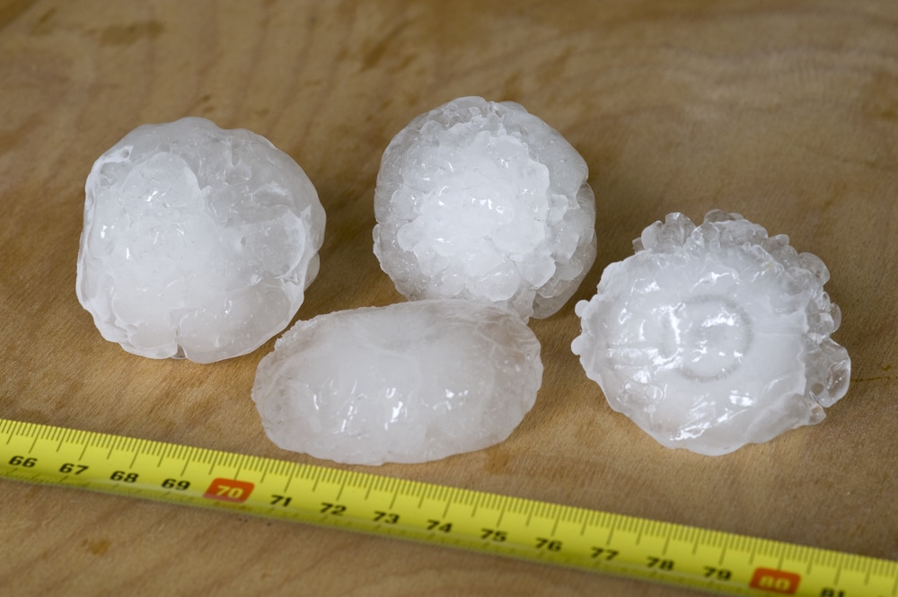
Hail the size of DVDs bombarded communities to the northwest of Lubbock, shattering windshields, damaging structures and even leaving small craters in fields and farmland.
In an unusual turn of events, the biggest hail report, at nearly five inches in diameter, came from … me. I happened to be storm chasing and was stationed in the town of Pettit, Tex., about 40 miles northwest of Lubbock, where I encountered hail larger than grapefruits.
I had pre-chilled a mobile freezer down to 24.8 degrees Fahrenheit to preserve hailstones in the off chance that I happened upon something noteworthy. As luck would have it, I did.
My report prompted the Weather Service to issue a warning for hail five inches in diameter. Examination of a database of Weather Service warnings indicates that this was first such warning among the 122 Weather Forecast Offices serving the United States and its territories since at least 2010.
While Weather Service forecasts have highlighted the potential for hail this big in watches, I could find no record of warnings for DVD-sized hail.
On rare occasions, Weather Service meteorologists issue warnings for softball-sized or grapefruit-sized hail, which corresponds to hail that is four or 4.5 inches in diameter, respectively.
Five-inch hail is an option for forecasters to select in WarnGen, the program the Weather Service uses to construct and disseminate warnings, but no prior instance of such usage was found.
In general, it’s difficult to confidently distinguish softball, grapefruit and larger hail on radar unless there are ground-based reports, which don’t typically come until after the fact.
Upon entering the storm, I had seen that hail as big as softballs was falling. An initial severe thunderstorm warning, issued at 5:26 p.m., warned of tennis-ball-size hail. The slow-moving storm was only moving east at 25 mph. At 6:08 p.m., the warning was extended east and three-inch hail was advertised.
That’s around the exact time that hail the size of baseballs and a few softballs began crashing to Earth in Pettit. Meteors of ice exploded into blurred shards as they shattered on the paved surface in front of me. I could tell a few were bigger than four inches across.
I ducked outside once again and found even bigger hailstones. Unfortunately, I couldn’t measure the hail at that moment because my calipers were buried in a crate. But I couldn’t risk leaving the hail outside the freezer for more than a few moments. Instead, I lined up two Hampton Inn room keys (3.375 inches in length), noted that the largest stone was a little more than 1.4 room key lengths, and calculated the maximum dimensions to be between 4.72 and 4.89 inches. I called the Weather Service again.
When large hail began to crash down yet again, I sought refuge in my vehicle once more. After the hail, I found several other stones between 4.5 and 4.7 inches in diameter that had been lying — and slowly melting — for nearly 20 minutes. I gingerly placed them into the freezer (which plugs into my vehicle’s cigarette outlet) and stored them at 12.2 degrees. Then I texted Ian Giammanco, lead scientist for the Insurance Institute for Business and Home Safety, that I had a “freezer full of hail.”
“Want it?” I asked. A few hours later, we met up and I turned over the stones. His group is working to scan them in three dimensions for research, as well as take detailed mass and diameter measurements.
He confirmed that one of the stones weighed a third of a pound, with a diameter of 4.63 inches.
That would make it a record for Hockley County, Tex., beating out the previous record of 4.5 inches from April 29, 2012. The same storm caused $25 million in damage and blasted a swath from Levelland to Ropesville with 95 mph winds. Archived storm reports indicate that, because of wind-driven hail, “the west-facing exterior of homes in these areas was completely shredded.”
The jumbo stone that I collected is still a far cry from the Texas state record hailstone, a “gargantuan” 6.4-inch monster that fell on Hondo, west of San Antonio, on April 28, 2021.
Interestingly, Tuesday’s DVD-dropper was the second hailstorm to affect Hockley County, Tex., in under two hours. As it turns out, the first storm exhaled cool air, which actually helped build the second supercell through a chain-reaction process.
“We found in research that sig-severe hailstorms often form in the cool outflow behind a previous storm,” Cameron Nixon, an atmospheric scientist, posted on X on Monday.
Many parts of Texas were rocked by severe weather Tuesday. Violent storms that swept through both Dallas and Houston unleashed gusts over 70 mph and cut power to nearly 1.4 million customers at one point.


