
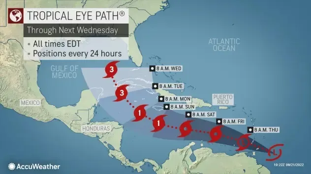
A developing tropical system could spin up into a hurricane in the Gulf of Mexico by the middle of next week, forecasters warned Wednesday.”This is the most significant threat for the U.S. mainland we’ve had this hurricane season,” AccuWeather chief meteorologist Jonathan Porter said.
The system, known now as Invest 98L, was located near the northeastern coast of South America on Wednesday. An “Invest” is an area that the National Hurricane Center is watching closely with advanced computer models and other resources, including the Hurricane Hunters, for possible development, according to Weather.com.
Most computer models predict the system will be a tropical storm by the weekend in the Caribbean. The models then show the system strengthening into a hurricane by early next week. If it becomes a named storm, it would be called Hermine.
According to Weather.com, the majority of computer forecast models curl the system – probably at hurricane strength – northward into the Gulf of Mexico around the middle of next week. Meteorologist Ryan Maue tweeted Wednesday that if the GFS computer model is right, “then this is what we’re dealing with: A major hurricane in the eastern Gulf of Mexico with impacts to the Florida Panhandle. But, all interests along the Gulf Coast from Houston to Key West should monitor for next few days when we’ll know more.”
It does not appear this system will be a threat to areas in the northeastern Caribbean, including Puerto Rico and the Dominican Republic, which were hit hard by Hurricane Fiona over the past few days, according to AccuWeather.
In addition to Fiona, which will graze Bermuda and then head for eastern Canada this week, forecasters were also monitoring Tropical Storm Gaston in the Atlantic Ocean. Gaston could bring strong winds and high surf to the Azores later this week, the National Hurricane Center said. (USA Today)


