
(ETH) – Western Australia is in the crosshairs for a triple threat as the Bureau of Meteorology (BOM) has just issued a warning to residents living on the coast of Western Australia to brace for intense winds, rain, and possible flooding as Tropical Cyclone “Seroja” is expected to pass between Carnavon and Jurien Bay on late Sunday or early Monday, April 11th or 12th.
In what is being deemed a rare weather event, two other potentially strong storms are also looming west of WA, with forecasters warning of the potential of these storms striking the area over the coming days.
The first storm called Seroja is forecasted to intensify again from Thursday to Saturday, April 8th to 10th, into a Category 3 storm, packing winds of up to 157 km/h (96 mph) and gusts peaking at 225 km/h (140 mph), before crossing the coast on Sunday. This storm has already reportedly claimed the lives of more than 150 people as it formed near Indonesia.
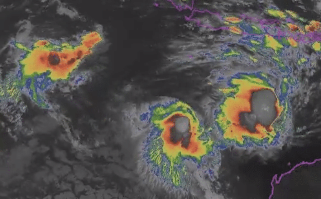
Triple threat: Satellite loop shows Tropical #CycloneSeroja (furthest right) joined by two other tropical lows west of #WA.
TC Seroja is forecast to impact the west coast of WA later this weekend, focussed between #Perth and Coral Bay.
Latest 🌀info:https://t.co/4tahnt9I4V pic.twitter.com/DgakUa2BbJ
— Bureau of Meteorology, Australia (@BOM_au) April 7, 2021
Then we have the second storm, which has been dubbed 23U, and is south of Christmas Island, which may have an effect on Seroja as it slowly moves south. This system is expected to intensify into cyclone level as it starts moving toward Western Australia.
“On Sunday it is expected to turn to the southeast towards the west coast and make landfall, most likely late Sunday or early Monday between Carnarvon and Jurien Bay,” it stated. “There is likely to be destructive winds, very heavy rainfall, and higher than normal tides close to Seroja’s path.
The most intense rainfall, with the associated danger of flash flooding, will be close to Seroja’s track, while the strongest winds will be just to the north of its track.” The third storm, deemed 24U, is located near Cocos Islands, and is also accelerating east and may form into a cyclone. As of the present, this system is considered to be the least threat to the land.


