
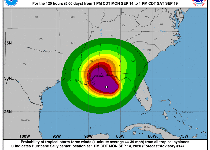
(OPINION) Michael Snyder – After everything else we have been through in 2020, now here comes Hurricane Sally. It is the seventh hurricane of the 2020 Atlantic hurricane season, and it could end up being the most destructive.
On Monday it strengthened into a Category 2 hurricane with 100 mph winds, and we are being told that it could potentially become a Category 3 storm before it finally makes landfall. But the wind speed is not what makes this storm potentially so dangerous.
Hurricane Sally is expected to slow down significantly as it approaches the Gulf Coast, and we are now being told that some areas could see up to two feet of rain. That could mean “life-threatening flooding”, especially if this storm directly hits New Orleans.
We all remember what happened when Hurricane Katrina hit the city of New Orleans in September 2005. Since that time, we have not seen a hurricane directly hit the city of New Orleans during the month of September, and this is something that I have been tracking every year. At this hour, we still don’t know where Hurricane Sally will make landfall.
It is heading toward New Orleans, but some forecasters expect it to make a very sharp turn to the north right before it gets there. But what if it doesn’t? In 2005, Hurricane Katrina was a Category 3 storm when it finally reached New Orleans, and it is anticipated that Hurricane Sally will be a Category 2 or a Category 3 storm when it ultimately makes landfall.
In fact, weather.com says that “additional strengthening is anticipated” in the hours ahead… Hurricane Sally has rapidly intensified and additional strengthening is anticipated as it tracks toward the northern Gulf Coast, where it will bring an extremely dangerous storm surge, flooding rainfall, and damaging winds early this week.
Sally will also pose a threat of flooding rainfall farther inland across parts of the Southeast. So if Hurricane Sally is already a Category 2 storm right now, it would seem likely that it would reach Category 3 at some point. But what makes this storm so unique is that it is supposed to move extremely slowly once it reaches the Gulf Coast, and that could mean “up to 48 hours of storm surge and rainfall”… READ MORE


