
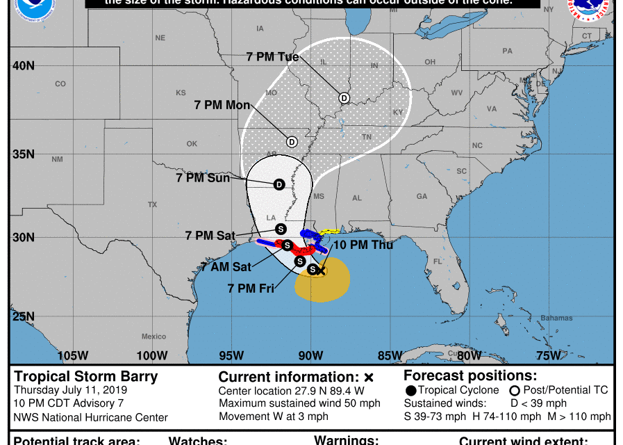
OPINION (MS) – New Orleans is about to be hit by “an extreme rainfall event” that is likely to be the worst disaster that the city has seen since Hurricane Katrina. It is being projected that Tropical Storm Barry could officially become a hurricane before it makes landfall on Saturday, but in this case, the wind speed is not really that important. Instead, the massive amount of rain that this immense storm will dump on southern Louisiana is the greatest danger, because the region is potentially facing flooding that is absolutely unprecedented. In fact, one weather expert is even warning that the flooding could be so dramatic that it might actually “change the course of American history”… Weather expert Eric Holthaus warned that,
while the impending disaster would be “an entirely different type” of flooding than 2005’s Katrina, it could be just as harmful – and might even “change the course of American history.” So why is there so much concern? Well, the NOAA is now projecting that some portions of southern Louisiana could get up to 25 inches of rain from this storm… The NOAA Weather Prediction Center (WPC) upped its rainfall forecast for Barry on Thursday afternoon, calling for a pocket of 20-25” amounts near Barry’s track between Thursday and Sunday evening. It’s very unusual for an NOAA/WPC forecast to depict amounts above 20”, which testifies to the center’s high confidence in this extreme rainfall event. READ MORE


